




MARION Marion will show residents four possible routes for a bike and walking path along Point Road on Wednesday, Nov. 18, the next link in a planned path from Mattapoisett through Marion toward Wareham.
The public information session starts at 6 p.m. at Marion Music Hall, 164 Front St., according to a notice the Department of Public Works posted Thursday. The town is holding it with its consulting engineers, TEC, Inc., and the Massachusetts Department of Transportation, and the notice says the session will "present and discuss the feasibility of proposed alternatives" for the path.
The proposed path would run along Point Road from Route 6 and connect to the shared use path MassDOT lists as project 607979, which runs from the Mattapoisett town line to Point Road. "The intent of the proposed Point Road SUP is to improve bicycle and pedestrian connectivity within the community," the notice says.
The four options
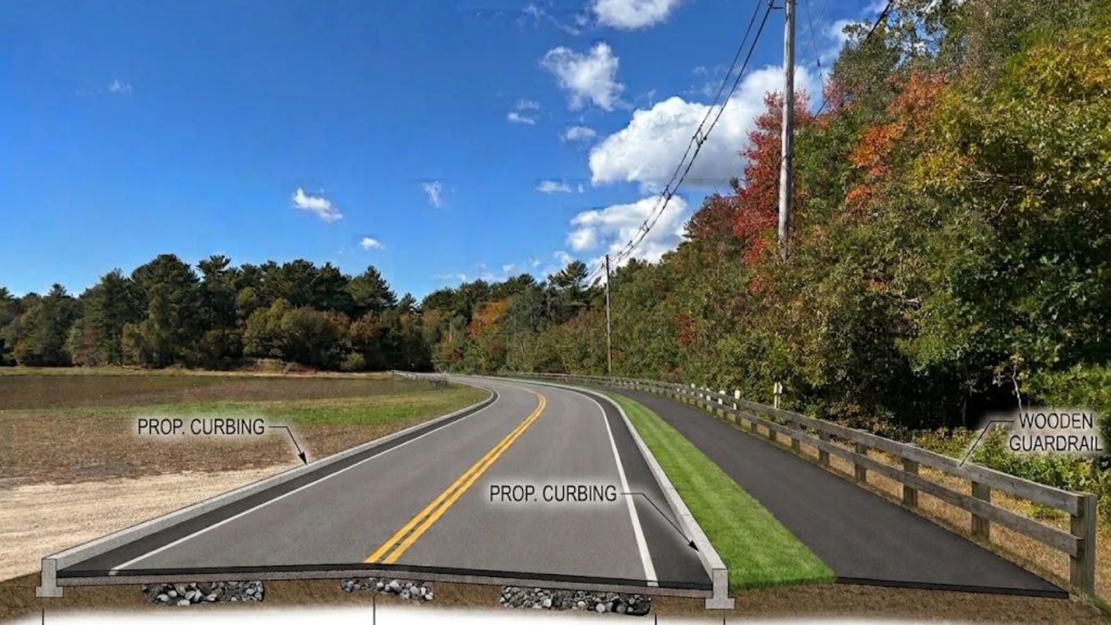
The town posted a 16-sheet set of plans ahead of the session, dated November 2026 and drawn at 1 inch to 50 feet. Each option takes four sheets to run the path from the County Road end, by Interstate 195, to Route 6 near Barros Drive, and every sheet lists the pros and cons of its option. Three of the four put a 10-foot path beside two 10-foot travel lanes with 2-foot shoulders for most of the route, separated from the road by a 5-foot strip of grass.
Option 1 keeps that full-width path where it fits but shifts the road to hold down easement and land needs on the south side of Point Road, and the plans say it avoids what they call the eastern Point Road pinch points. The trade-offs listed are the effect on trees and brush along the north side of the road and a narrower path and buffer along the eastern part of the street. The plans estimate about 930 square feet of easement or land would be needed.
Option 2 shrinks the path to 8 feet with a 2-foot buffer of grass or hard surface, which narrows the whole cross section and keeps a direct route along Point Road. The plans say the constraints at the eastern end remain, and they estimate about 865 square feet of easement or land, the smallest of the four.
Option 3 carries the full 10-foot path and grass buffer the whole way along Point Road, with a railing beside a wetland. The plans flag what they call significant constraints in the eastern segment and a possible effect on drainage and a culvert near the bog, and they estimate about 7,550 square feet of easement or land.
Option 4 runs the full-width path and buffer along Point Road past the cranberry bogs, with a possible scenic overlook, then turns off Point Road onto Barros Drive and Whynot Court, keeping at least 20 feet of roadway on those streets, and reaches Route 6 on an off-road stretch along an Eversource utility easement. The plans list its drawbacks: Barros Drive and Whynot Court are privately owned, the route needs Eversource coordination and an easement, and the off-road segment faces environmental and permitting limits. It needs the most land, about 17,060 square feet.
Driveways, poles and parking
Every option keeps all existing driveway openings, according to the plans. Near County Road they suggest a possible road diet to narrow the travel lanes, shared lane markings between County Road and the path, and an optional rectangular rapid flashing beacon for pedestrians. Where utility poles conflict with the path, the plans suggest moving them to the other side of the road or widening the buffer around them. At the Route 6 end they suggest building a parking lot within the Point Road park or widening the town gravel lot, and a link to a future Route 6 path.
Several options would also remove roadside vegetation inside the right of way and add wood rail fencing along the tree line or at the bog, and three of them shift the road to stay clear of what the plans call critical environmental habitats and rare species bio-cores. The plans carry a caution on every sheet: property and right-of-way lines are approximate and have not been field verified. They give no cost for any of the four routes.
The path it would join
The Point Road path would join phase 1 of the town's shared use path, which Marion and MassDOT have proposed from the Mattapoisett line to Point Road. The town's January 2024 fact sheet on that project describes about 3.8 miles of path for biking, walking and jogging, mostly on an abandoned railroad and trolley bed, and calls it a connection point between Mattapoisett's existing path and one proposed in Wareham, part of the planned 50-mile South Coast Bikeway from Rhode Island to Cape Cod. The fact sheet put the cost at that time at about $5.49 million, paid with federal and state money.
How to weigh in
The four options, plus a rendering of a pinch point and one of the north side of the bog, are posted on the Department of Public Works page of marionma.gov for anyone to review before the session. The DPW office, 508-748-3540, is open weekdays from 7 a.m. to 3:30 p.m.
Label: Reported by us, from the town's posted records.
Notes
Every fact comes from the Town of Marion's Nov. 12 notice of the Point Road Shared Use Path information session, its Department of Public Works page, the 16-sheet alternatives plan set the town posted with it, and the town's January 2024 fact sheet on the phase 1 path. We read each record on Nov. 12 and checked each date and weekday against a calendar.
Corrections
No corrections to this story. If something here is wrong, tell us. Every correction is dated on the story and listed in our public log.
Sources (4)
- Town of Marion, Notice of Public Information Session: Point Road Shared Use PathTown of Marion News Flash, posted Nov. 12, 2026. Session Wed. Nov. 18, 6 p.m., Marion Music Hall; TEC, Inc. and MassDOT; connection to MassDOT SUP No. 607979. Read Nov. 12, 2026.
- Town of Marion, Department of Public WorksTown of Marion. The same notice dated Nov. 12, 2026, the links to the alternatives and the two renderings, and the DPW office hours. Read Nov. 12, 2026.
- Marion Local Early Actionable Planning Program (LEAP) Alternatives, Point Road shared use pathTEC, Inc. for the Town of Marion, 16 sheets dated November 2026, file dated Oct. 28, 2026. Alternatives 1 to 4, cross sections, pros and cons, estimated easement or acquisition areas of 930, 865, 7,550 and 17,060 square feet. Read Nov. 12, 2026.
- Town of Marion Shared Use Path Project Description (fact sheet), Jan. 31, 2024Town of Marion. About 3.8 miles from the Mattapoisett and Marion town line to Point Road, mostly on a former railroad and trolley bed; a connection point between the Mattapoisett path and one proposed in Wareham on the South Coast Bikeway; program cost about $5.49 million in federal and state money. Read Nov. 12, 2026.