


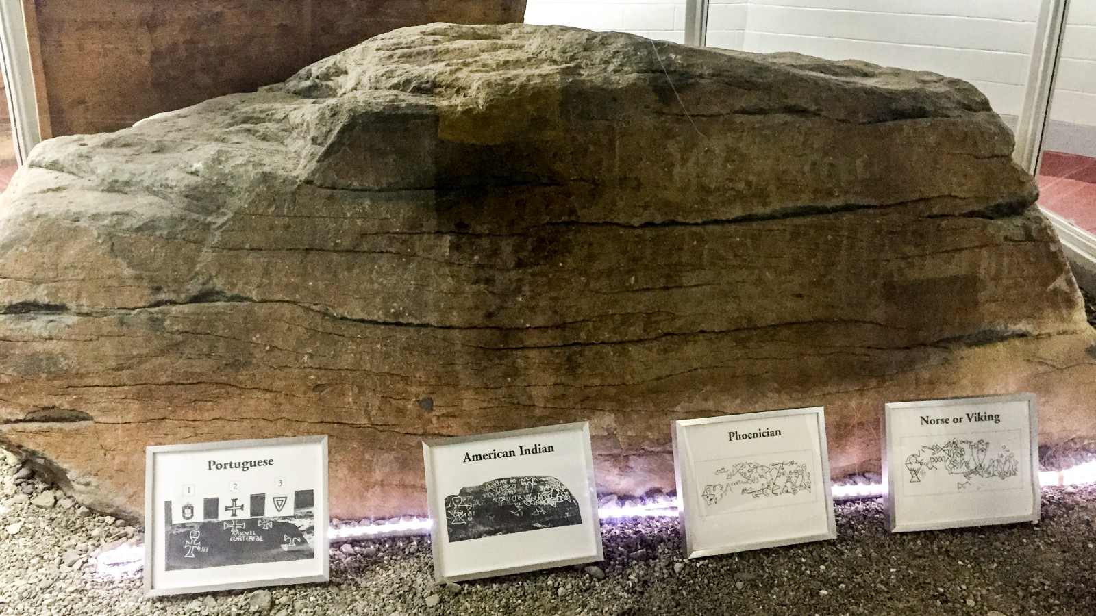

DIGHTON The Rev. John Danforth drew part of the carvings on a boulder at the edge of the Taunton River in October 1680, and people have argued over who made them ever since. Dighton Rock, which sits across the river from the town of Dighton, has been credited to Phoenician sailors, Norse explorers, a lost Portuguese captain and the Native people who lived on the riverbank. In a 1971 nomination to the National Register of Historic Places, the Massachusetts Historical Commission called the origin of its carvings "one of America's historic mysteries." The rock no longer sits in the tide. The state raised it in 1964, and it is now kept indoors at Dighton Rock State Park in Berkley.
What is on the rock
Edmund Burke Delabarre, a Brown University psychology professor who spent years on the rock, described it in his 1928 book, Dighton Rock: A Study of the Written Rocks of New England, as "a gray, medium to coarse grained feldspathic sandstone boulder" with a nearly flat face turned toward the river. He measured that face at about 11 feet long and 4 feet 10 inches at its highest, probed the mud around it and calculated that the whole stone weighed "not far from forty tons," with about seven-tenths of it underground. It sat on the beach between the high and low water marks, and the most moderate high tides covered it completely.
The face, Delabarre wrote, is nearly covered with lines "pecked in with some sharp tool." He built a gauge to measure them and found most were 2 millimeters deep or less. Visitors added their own initials and dates over the years. He listed only a handful of figures that nearly every observer agreed on: "A large human figure midway between centre and left end, two smaller ones at extreme right, two complex figures made up of triangular forms at the top, and a peculiar quadruped with horns, near the centre." The rest, he wrote, ran "about everywhere in incomprehensible jumbles," and the drawings people made of the rock were so different "that it seems almost impossible at first sight to believe that they represent the same object."
The first drawings
The rock sits on Assonet Neck, which Delabarre wrote belonged to the Wampanoag until the end of King Philip's War. Plymouth Colony claimed the neck by conquest in 1676 and sold it to six proprietors on Nov. 12, 1677, and in a division of March 23, 1680, the piece with the rock went to James Walker of Taunton. Danforth's drawing from that October survives among the manuscripts of the British Museum, according to Delabarre, who obtained photographs of the originals. Cotton Mather published a drawing of part of the inscription in 1690 in The Wonderful Works of God Commemorated, writing of a rock "filled with strange Characters," and Delabarre concluded from comparing the two that "Mather copied from Danforth, and that he was a very poor copyist."
Phoenicians, Norsemen and a Portuguese captain
The first full translation came from France. Antoine Court de Gebelin, working from a 1768 drawing by Harvard professor Stephen Sewall, published the eighth volume of his Le Monde Primitif in 1781 and argued that the carving was made "in very ancient times by Phoenicians," a record of Carthaginian sailors who lived for a while among the local people, Delabarre wrote. Ezra Stiles, the president of Yale College, took up the idea in a 1783 Election Sermon before the governor and General Assembly of Connecticut, saying the Phoenicians had marked this and other rocks around Narragansett Bay with Punic inscriptions "remaining to this day."
Danish scholar Carl Christian Rafn, who was gathering the Icelandic manuscripts on the Norse discovery of America, asked the Rhode Island Historical Society in 1829 whether the Norsemen had left any traces on the American coast, and a society committee drew the inscription in 1834 and sent the drawing to Copenhagen. In his 1837 book Antiquitates Americanae, Rafn and his colleague Finn Magnusen read the Roman numeral CXXXI and the words NAM THORFINS in the lines. Counting the C as the Icelandic "great hundred" of 120, Rafn made the numeral 151, the number of Thorfinn Karlsefni's men in the sagas after nine of them left. When Delabarre got copies of the society's original drawings from Denmark, he found lines Rafn had added. "Rafn attempted to distinguish his own additions by drawing them with shaded lines," Delabarre wrote. "Unfortunately, the shadings are not very distinct, and are easily overlooked."
Ownership of the rock went to Denmark, too. On June 23, 1860, Niels Arnzen of Fall River, who had bought it at the request of the violinist Ole Bull, gave it to the Royal Society of Northern Antiquaries in Copenhagen. The society passed it to the Scandinavian Memorial Club of Boston in 1877, and because the club could not legally own property, deeded it again on Jan. 30, 1889, to the Old Colony Historical Society of Taunton, Delabarre wrote.
Delabarre, whose summer home stood within a mile or two of the rock, came up with the Portuguese reading. Studying flashlight photographs, including one he took at 3 a.m. on July 17, 1920, he found what he read as the date 1511, the name Miguel Cortereal and the abbreviated Latin words "V. DEI hIC DVX IND." He expanded them to "Voluntate Dei hic Dux Indorum," which Edward Brecher, writing in American Heritage in 1958, translated as "by the will of God, here leader of the Indians." Miguel Corte-Real, as the name is usually spelled now, sailed to Newfoundland in 1502 to search for his brother Gaspar, and neither returned. "The strongest assertion that I am willing to make is that the name is almost surely there," Delabarre wrote. He also argued that the Native carvings on the rock came later, "from about 1640 to about 1675," made in imitation of the Europeans' writing.
What scholars and the government said
A 1952 National Park Service report, kept in the rock's National Register file, collected the reviews of Delabarre's book. It quoted Charles C. Willoughby of Harvard's Peabody Museum, who wrote in 1929 that "a few of the characters can be traced without difficulty in his illustrations, but the majority of them appear to be too obscure for unqualified acceptance," and Truman Michelson, who wrote in 1930 that "a very few characters may have values assigned by Dr. Delabarre, but the rest can not be accepted." On Nov. 17 and 18, 1952, the federal Advisory Board on National Parks, Historic Sites, Buildings and Monuments resolved that "judgment in the case should be suspended until new techniques are devised for recording the markings on the rock," and that the Old Colony Historical Society and the state, not the federal government, should protect it.
In 1960, Dr. Manuel Luciano da Silva of the Miguel Corte Real Memorial Society in New Bedford wrote to President Dwight D. Eisenhower asking for American recognition of the rock's importance. The draft reply the Interior Department prepared for the White House, kept in the same file, said "general agreement does not exist among scholars in this Country regarding the significance of the Rock." The state's 1971 nomination counted more than 600 books and articles and some 35 theories, called Delabarre's explanation the most popular and concluded that "it now seems unlikely that there will ever be definitive evidence in support of any one of them."
Later scholars have pointed to the people who lived on the river. Douglas William Hunter, in a 2015 dissertation at York University, wrote that the Indigenous origin of the rock's essential markings "has never been seriously contested" and argued that crediting them to Old World visitors was part of the wider Euro-American colonization project. On a 2017 tour of the museum, archaeologist Ellen Berkland described 3-D imaging that has confirmed Native American authorship of the carvings, the Harvard Gazette reported, and said, "We'll finally be able to put the story to rest."
How the rock left the river
Moving the rock was proposed for more than a century before it happened. Delabarre listed a plan to take it to Fall River in 1829, a Rhode Island Historical Society idea to buy it in 1838, the Danish society's intention between 1861 and 1864 to ship it to Denmark, and an 1877 proposal from the committee building the Leif Erikson statue in Boston to bring it to that city, and each was abandoned. In 1955 the Old Colony Historical Society deeded the rock to the state, and the Legislature set aside money for a state park with the rock moved to higher ground, Brecher wrote in 1958.
A National Park Service survey card dated Feb. 20, 1959, said a study done for the state by Joseph Hartshorn of the U.S. Geological Survey and Frederick Johnson of the Robert S. Peabody Foundation recommended "so elaborate a set of methods and precautions" that the plan was dropped and shelved. In 1964, the state Department of Natural Resources raised the stone to its present level and built a landfill under it, forming a promontory, according to the 1971 nomination. Out of the water, the rock was reddening through a chemical reaction with iron compounds and was "in danger of drying out and crumbling," the nomination warned, and the department proposed a building over it to serve as a shelter and a tourist center. A clipping in the federal file lists $10,720.50 for "construction of a facility to protect the rock from air damage and discoloration." The Harvard Gazette, in its 2017 account, dated the rock's removal from the river to 1963 and the museum to 10 years later.
Seeing it now
Dighton Rock State Park is on the Berkley shore of the Taunton River, and the rock sits inside the museum there. In a 2015 photograph of the exhibit, four placards along its base set out four readings: Portuguese, American Indian, Phoenician, and Norse or Viking. The Harvard Gazette described a Department of Conservation and Recreation ranger leading visitors through the museum on the 2017 tour.
Current hours and directions are on the state Department of Conservation and Recreation's Dighton Rock State Park page.
Read it yourself
- Delabarre's 1928 book is a public domain scan on the Internet Archive. Chapter 2 describes the rock, Chapters 4 to 7 cover the Phoenician, Norse and Native theories, and Chapter 10 sets out his Corte-Real reading.
- The rock's National Register file, with the 1971 nomination, the 1952 Park Service report and the 1960 letters, is on the National Park Service's NPGallery site under number 80000438.
- Brecher's 1958 American Heritage article, The Enigma of Dighton Rock, is free to read on the magazine's site, and Hunter's dissertation, Stone of Power, is in York University's YorkSpace library.
Label: Reported by us, from the town's posted records.
Notes
The description of the rock, its early record, the Phoenician, Norse and Portuguese readings and the ownership history to 1889 come from Edmund Burke Delabarre's Dighton Rock: A Study of the Written Rocks of New England (1928). The 1952 reviews and Advisory Board resolution, the 1959 survey card, the 1960 White House correspondence and the 1964 raising of the rock come from the rock's National Register file at the National Park Service, including the Massachusetts Historical Commission's 1971 nomination. The 1955 deed to the state comes from Edward Brecher's 1958 American Heritage article, and the 2017 museum tour from the Harvard Gazette. Where accounts differ on a year, the story says so. We read them on Oct. 30 and checked each date against a calendar. Not heard: no one was contacted.
Corrections
No corrections to this story. If something here is wrong, tell us. Every correction is dated on the story and listed in our public log.
Sources (8)
- Edmund Burke Delabarre, Dighton Rock: A Study of the Written Rocks of New England (New York, Walter Neale, 1928) | Internet ArchiveTitle page, preface and contents checked; Chapter II read in full (pp. 19 to 27); the passages used from Chapters III, IV, VI, VII, X and XVIII read in context (pp. 28 to 34, 50 to 61, 86 to 98, 108 to 110, 165 to 173, 184 to 185, 302 to 305). Public domain (Internet Archive: not in copyright). Read Oct. 30, 2026.
- Dighton Rock, National Register of Historic Places, NRIS 80000438 | National Park Service NPGalleryRecord page: resource type object, significant year 1964, location across the Taunton River from Dighton in Dighton Rock State Park. Read Oct. 30, 2026.
- Dighton Rock National Register file (40 pages) | National Park Service NPGalleryMassachusetts Historical Commission nomination dated March 30, 1971; 1952 Park Service report by Edwin W. Small dated Oct. 18, 1952; Advisory Board resolution of Nov. 17 and 18, 1952; 1960 covering briefs and draft White House replies to Dr. Manuel Luciano da Silva; survey card dated Feb. 20, 1959; undated grant clipping. Text layer read in full; pages 2, 3, 11, 12, 13, 39 and 40 checked against the page images. Read Oct. 30, 2026.
- Edward Brecher, The Enigma of Dighton Rock, American Heritage, June 1958 (Vol. 9, No. 4) | American HeritageRead in full: Mather 1690 quotation, Delabarre and the 1511 reading, translation of the Latin, 1955 deed to the state and the park plan. Read Oct. 30, 2026.
- Harvard Art Museums tour takes visitors to Dighton Rock, Harvard Gazette, Sept. 15, 2017 | Harvard UniversityRead in full: 1963 removal, museum about 10 years later, DCR ranger tour, archaeologist Ellen Berkland on 3-D imaging. Read Oct. 30, 2026.
- Douglas William Hunter, Stone of Power: Dighton Rock, Colonization and the Erasure of an Indigenous Past (dissertation, York University, 2015) | YorkSpaceCatalog record and abstract read in full. Read Oct. 30, 2026.
- Dighton Rock State Park | Massachusetts Department of Conservation and RecreationLinked for readers. Current hours are on the state's page and are not stated in this story.
- Dighton Rock State Park, Berkley MA.jpg (Kenneth C. Zirkel, July 3, 2015) | Wikimedia CommonsLead photo, CC BY-SA 4.0, attribution required; file sha1 6ba5c9890600fcfb2d8aff0ececdf1d3d606be02. Read Oct. 30, 2026.