




SOUTH COAST Rain is in the forecast across the South Coast Sunday night and may be heavy at times Monday, with a strong coastal storm expected to affect the region, the National Weather Service's Boston/Norton office said Thursday.
The office's zone forecast, issued at 4:02 a.m., puts the chance of rain near 100 percent Sunday night in the southern Bristol County zone, which includes Fall River and New Bedford, and in the eastern and southern Plymouth County zones, and at 90 percent in the northern Bristol County zone around Taunton. Monday's chance is 90 percent in all four. No watch, warning or advisory was in effect for Massachusetts when we checked the Weather Service's active alerts at 5:34 a.m. Thursday.
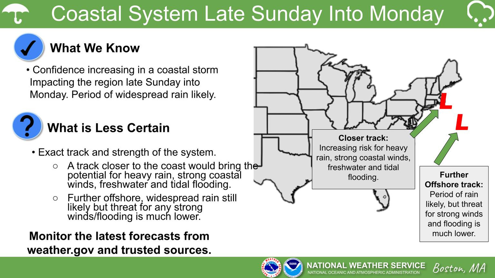
The storm is still days off, and the forecasters wrote in their 3:24 a.m. discussion that "there remains considerable uncertainty on the track/strength/potential impacts." A graphic the office posted early Thursday sets out both cases: a track closer to the coast would bring the potential for heavy rain, strong coastal winds and freshwater and tidal flooding, while farther offshore, "widespread rain still likely but threat for any strong winds/flooding is much lower."
How much rain
"Confidence is increasing for the potential of a windswept heavy rain with significant marine impacts late Sunday into Monday," the discussion says. The forecasters expect energy now over Florida to become a coastal storm off Florida's east coast this weekend, then "rapidly intensify as it tracks northeast," likely passing near or possibly northwest of the 40N/70W benchmark, the point south of Nantucket that New England forecasters use to judge a storm's track. The storm "may obtain sub-tropical characteristics," they wrote.
The overnight runs of the American and European global models track it near the benchmark, which would mean a soaking rainfall of 1 to 3 inches across eastern Massachusetts and Rhode Island, "but the worst of it would be out over the ocean," the forecasters wrote. The AI versions of those two models, and Google's AI model, take it farther west, and the forecasters wrote of a concern that the model solutions may end up there, with the potential for a swath of 3 to 5 inches of rain or more. "Whether or not this occurs remains to be seen," they wrote, but it "would certainly raise our concerns for fresh water flooding."
In the zone forecast, the southern Bristol County zone and the southern Plymouth County zone, which includes Mattapoisett, have rain with a chance of thunderstorms Sunday night, and "some thunderstorms may produce heavy rainfall." Temperatures hold near steady in the mid 50s overnight, and Monday's highs are in the lower 60s.
High tides and the coast
Astronomical high tides "will be on the increase," the discussion says, and if the storm takes a track farther west, "the potential exists for tidal flooding." NOAA's tide predictions for New Bedford Harbor show a high tide of 4.2 feet above mean lower low water at 5:27 a.m. Sunday and 3.6 feet at 5:55 p.m. Sunday. Monday's morning high tide is 4.5 feet at 6:18 a.m., followed by 3.8 feet at 6:46 p.m. Monday morning's tide is about half a foot above the harbor's average daily higher high tide, which NOAA's tidal datums put at about 4 feet.
At NOAA's Fall River station, Monday's morning high tide is predicted at 5.3 feet at 6:21 a.m., and at Woods Hole it is 2.7 feet at 6:35 a.m. NOAA lists the Weather Service's minor flood level at the Fall River station at about 7 feet above mean lower low water, roughly 1.7 feet above Monday morning's predicted high tide. The forecasters tie any tidal flooding to a track farther west.
On the water
The coastal waters forecast issued at 4:03 a.m. has Buzzards Bay under southeast winds of 15 to 20 knots Sunday night, with gusts up to 25 knots, seas of 2 to 3 feet and rain. Monday turns to northwest winds of 20 to 25 knots with gusts up to 30 knots and seas of 4 to 6 feet. The forecast's synopsis says a strong low "may then develop into a Gale center and track near the 40N/70W benchmark on Mon." For the coastal waters as a whole, the discussion gives a moderate risk of gale-force winds Monday with local gusts up to 45 knots and rough seas up to 23 feet.
Before and after the storm
The zone forecast keeps the South Coast dry and sunny through Saturday, with highs in the 60s Thursday and Friday, and much colder air follows the storm. In both Bristol County zones, Monday night's lows are in the lower 30s, and Tuesday is mostly clear with highs in the lower 40s before lows in the lower 20s Tuesday night, the zone forecast says. The forecasters called it "a significant change from the very mild weather we have been experiencing much of the month."
Our Tuesday story on the week ahead first reported the Weather Service watching this storm, when its track was far less certain.
What happens next
The National Hurricane Center, in its outlook issued at 1 a.m. Thursday, said a non-tropical low is expected to form near the northern Bahamas by late Friday and could become a subtropical or tropical storm as it moves north or northeast near or just offshore of the southeastern U.S. coast through the weekend. It gives the system a 60 percent chance of forming within seven days, and it said, "Interests along the eastern U.S. coast should monitor the progress of this system."
The Boston/Norton office updates its forecast discussion and zone forecasts several times a day. We will update this story as the Weather Service narrows the storm's track and amounts, and when it issues any watch, warning or advisory for Bristol or Plymouth County.
Label: Reported by us, from the town's posted records.
Notes
Every forecast in this story is the National Weather Service's or NOAA's, read early Thursday, Nov. 19: the Boston/Norton office's Area Forecast Discussion issued at 3:24 a.m., its Zone Forecast Product issued at 4:02 a.m. and its Coastal Waters Forecast issued at 4:03 a.m., the Weather Service's active alerts for Massachusetts, read at 5:34 a.m. with no watch, warning or advisory in effect, the office's weather story graphic posted early Thursday, the National Hurricane Center's Tropical Weather Outlook issued at 1 a.m., NOAA's tide predictions for New Bedford Harbor, Fall River and Woods Hole, NOAA's tidal datums for New Bedford Harbor and the Weather Service's minor flood level for the Fall River station as NOAA lists it. Quotes are word for word from the discussion, the zone forecast, the coastal waters synopsis, the graphic and the outlook. The tide comparisons are our arithmetic from NOAA's figures. The description of the 40N/70W benchmark is ours. We checked each date and weekday against a calendar.
Corrections
No corrections to this story. If something here is wrong, tell us. Every correction is dated on the story and listed in our public log.
Sources (12)
- National Weather Service Boston/Norton: Area Forecast Discussion, 3:24 a.m. EST Nov. 19, 2026What has changed, key messages 1 to 3, discussion (the storm off Florida, near or possibly northwest of the benchmark, 1 to 3 inches in the benchmark track, 3 to 5 inches or more in the AI model solutions farther west, freshwater and tidal flooding potential, colder Tuesday and Wednesday), marine outlook (moderate risk of gale-force winds Monday, local gusts to 45 kt, rough seas up to 23 ft), watches and warnings (none). Read 5:15 a.m. Nov. 19, 2026.
- National Weather Service Boston/Norton: Zone Forecast Product for Southern New England, 4:02 a.m. EST Nov. 19, 2026Zones MAZ017 Northern Bristol (Taunton), MAZ019 Eastern Plymouth (Plymouth), MAZ020 Southern Bristol (Fall River and New Bedford) and MAZ021 Southern Plymouth (listed by Mattapoisett): sky, temperatures and rain chances Thursday through Wednesday. Read 5:16 a.m. Nov. 19, 2026.
- National Weather Service Boston/Norton: Coastal Waters Forecast for Massachusetts and Rhode Island, 4:03 a.m. EST Nov. 19, 2026Synopsis (a strong low may develop into a gale center near the 40N/70W benchmark Monday) and zone ANZ234 Buzzards Bay winds, seas and rain Sunday night through Monday night. Read 5:16 a.m. Nov. 19, 2026.
- National Weather Service: active alerts for MassachusettsZero active watches, warnings or advisories at 5:34 a.m. Nov. 19, 2026 (feed updated 10:32 UTC).
- National Weather Service Boston/Norton: weather story graphic, Coastal System Late Sunday Into Monday, posted early Thursday, Nov. 19, 2026 (feed entry 4:18 a.m. EST)What we know (confidence increasing in a coastal storm late Sunday into Monday, a period of widespread rain likely) and what is less certain (a closer track brings the potential for heavy rain, strong coastal winds, freshwater and tidal flooding; farther offshore, rain still likely but the threat of strong winds and flooding is much lower). Read 5:30 a.m. Nov. 19, 2026.
- NOAA National Hurricane Center: Tropical Weather Outlook, Atlantic, 1 a.m. EST Nov. 19, 2026Offshore the Southeast U.S. coast: non-tropical low expected near the northern Bahamas by late Friday; could become subtropical or tropical; formation chance near 0 percent in 48 hours and 60 percent in 7 days. Read 5:16 a.m. Nov. 19, 2026.
- NOAA Tides and Currents: tide predictions, New Bedford Harbor (station 8447636)High and low tide predictions, Nov. 21 to 26, 2026, feet above mean lower low water, local time: 4.21 ft 5:27 a.m. and 3.60 ft 5:55 p.m. Nov. 22; 4.54 ft 6:18 a.m. and 3.80 ft 6:46 p.m. Nov. 23; morning highs rise to 4.76 ft Nov. 24 and 4.85 ft Nov. 25. Read 5:16 a.m. Nov. 19, 2026.
- NOAA Tides and Currents: tide predictions, Fall River (station 8447386)High tide 5.30 ft above mean lower low water at 6:21 a.m. Nov. 23, 2026. Read 5:16 a.m. Nov. 19, 2026.
- NOAA Tides and Currents: tide predictions, Woods Hole (station 8447930)High tide 2.72 ft above mean lower low water at 6:35 a.m. Nov. 23, 2026. Read 5:16 a.m. Nov. 19, 2026.
- NOAA Tides and Currents: tidal datums, New Bedford Harbor (station 8447636)Mean higher high water 3.99 ft above mean lower low water (1983 to 2001 epoch). Read 5:28 a.m. Nov. 19, 2026.
- NOAA Tides and Currents: flood levels, Fall River (station 8447386)National Weather Service minor flood level 27.85 ft on the station datum, where mean lower low water is 20.87 ft, so about 6.98 ft above mean lower low water. Read 5:29 a.m. Nov. 19, 2026.
- South Coast 360: Dry, sunny week for the South Coast, with rain possible Sunday into Monday, Weather Service saysOur Nov. 17 story on the week ahead, from the Weather Service products of that afternoon.